Fichier:PIA02405.jpg

Kiɖe tɛɛ takayaɣ (Kpaɣna pɩkɩsɛlɩ 7 238 nɛ pɩtalɩ 3 135 ñɩŋgʋ, takayaɣ walanzɩ : 2,2 Mio, MIME akɩlɩ : image/jpeg)
Kɛdɩtʋ
| Kɛdɩtʋ |
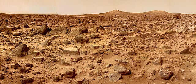
The Twin Peaks are modest-size hills to the southwest of the Mars Pathfinder landing site. They were discovered on the first panoramas taken by the IMP camera on the 4th of July, 1997, and subsequently identified in Viking Orbiter images taken over 20 years ago. The peaks are approximately 30-35 meters (-100 feet) tall. North Twin is approximately 860 meters (2800 feet) from the lander, and South Twin is about a kilometer away (3300 feet). The scene includes bouldery ridges and swales or "hummocks" of flood debris that range from a few tens of meters away from the lander to the distance of the South Twin Peak. The composite color frames that make up this "left-eye" image consist of 8 frames, taken with different color filters that were enlarged by 500% and then co-added using Adobe Photoshop to produce, in effect, a super-resolution panchromatic frame that is sharper than an individual frame would be. This panchromatic frame was then colorized with the red, green, and blue filtered images from the same sequence. The color balance was adjusted to approximate the true color of Mars. This image and File:PIA02406.jpg (right eye) make up a stereo pair. Mars Pathfinder is the second in NASA's Discovery program of low-cost spacecraft with highly focused science goals. The Jet Propulsion Laboratory, Pasadena, CA, developed and manages the Mars Pathfinder mission for NASA's Office of Space Science, Washington, D.C. JPL is a division of the California Institute of Technology (Caltech). The IMP was developed by the University of Arizona Lunar and Planetary Laboratory under contract to JPL. Peter Smith is the Principal Investigator. |
| Efemiye | |
| Kiɖe | http://photojournal.jpl.nasa.gov/catalog/PIA02405 |
| Mayʋ | NASA/JPL |
| Autres versions |
 |
Cette image ou vidéo a été cataloguée par le Jet Propulsion Lab de la National Aeronautics and Space Administration (NASA) des États-Unis sous Photo ID : PIA02405.Ce bandeau n’indique rien sur le statut de l’œuvre au regard du droit d'auteur. Un bandeau de droit d’auteur est requis. Voir Commons:À propos des licences pour plus d’informations. Autres langues :
|
Labɩnaʋ paɣtʋ
| Ce fichier provient de la NASA. Sauf exception, les documents créés par la NASA ne sont pas soumis à copyright. Pour plus d'informations, voir la politique de copyright de la NASA. | ||
 |
Attention :
|
Takayaɣ caanaʋ tɔm kɛdʋʋ
Tukina efemiye nɛ ñɩɣtʋ nɛ ŋna takayaɣ kanɛ ɛzɩ kaawɛʋ alɩwaatʋ ndʋ tɩ-taa yɔ.
| Efemiye nɛ ñɩɣtʋ | Tampɔɔ | Walanzɩ | Labɩnayʋ | Tɔm taa nuutuu | |
|---|---|---|---|---|---|
| lɛlɛɛyɔ | 25 Agoza fenaɣ 2007 à 16:42 | | 7 238 × 3 135 (2,2 Mio) | Clh288~commonswiki | {{Information |Description= The Twin Peaks are modest-size hills to the southwest of the Mars Pathfinder landing site. They were discovered on the first panoramas taken by the IMP camera on the 4th of July, 1997, and subsequently identified in Viking O |
Takayaɣ labɩnaʋ
Takayɩhayʋʋ kɩtɩŋʋʋ lakɩna takayaɣ kanɛ tʋmɩyɛ :
takayaɣ labɩnaʋ nɛ paa anɩ
Wikinaa kɩtɩŋaa lɛlaa lakɩna kɩlɛmʋʋ kʋnɛ nɛ tʋmɩyɛ :
- Labɩnaʋ ar.wikipedia.org yɔɔ
- Labɩnaʋ ast.wikipedia.org yɔɔ
- Labɩnaʋ bg.wikipedia.org yɔɔ
- Labɩnaʋ ca.wikipedia.org yɔɔ
- Labɩnaʋ ca.wikinews.org yɔɔ
- Labɩnaʋ cs.wikipedia.org yɔɔ
- Labɩnaʋ da.wikipedia.org yɔɔ
- Labɩnaʋ de.wikipedia.org yɔɔ
- Labɩnaʋ eml.wikipedia.org yɔɔ
- Labɩnaʋ en.wikipedia.org yɔɔ
- Labɩnaʋ en.wikivoyage.org yɔɔ
- Labɩnaʋ eo.wikipedia.org yɔɔ
- Labɩnaʋ es.wikipedia.org yɔɔ
- Labɩnaʋ eu.wikipedia.org yɔɔ
- Labɩnaʋ fi.wikipedia.org yɔɔ
- Labɩnaʋ fr.wikipedia.org yɔɔ
- Labɩnaʋ fr.wikinews.org yɔɔ
- Labɩnaʋ gl.wikipedia.org yɔɔ
- Labɩnaʋ hi.wikipedia.org yɔɔ
- Labɩnaʋ hu.wikipedia.org yɔɔ
- Labɩnaʋ id.wikipedia.org yɔɔ
- Labɩnaʋ it.wikipedia.org yɔɔ
- Labɩnaʋ kw.wikipedia.org yɔɔ
- Labɩnaʋ lt.wikipedia.org yɔɔ
- Labɩnaʋ mr.wikipedia.org yɔɔ
- Labɩnaʋ mwl.wikipedia.org yɔɔ
- Labɩnaʋ nl.wikipedia.org yɔɔ
Cɔna takayaɣ labɩnaʋ tɩŋa